
The lighthouse is located on the small open Harilaiu, 4 km southwest of the island of Vorms, and makes shipping safer in the northern part of the Väinamere, Harilaiu (Greser) and
On the shipping route between Soolarahu (Stengrund, Steinšer). The lighthouse has colored sectors of fire delimiting the dangers. In addition, it forms a target of 330.3° with the fire tank Est 586, located 178 m away at the same width, which leads through between Eerik kivi and Soolarahu.
The first signal light is said to have been installed on Harilaiu in 1849 at the initiative of Baron von Ungern-Sternberg of Suuremõisa. However, this fire tank was still missing from official sea charts and navigation guides several decades later.
1871. only the tavern building is noted on the island in the pilot book of 2008. According to the author, it could have been a signal light organized by the baron of Suuremõisa, which showed the location of the tavern in the darkness to the people traveling between the mainland and Hiiumaa and to the ships standing at anchor. Many sailing ships often waited for a favorable wind in a favorable anchorage. Harilaid was also an unofficial transit station for passengers from Hiiumaa and Lääne County who wanted to board ships traveling between St. Petersburg, Tallinn, Pärnu and Riga.
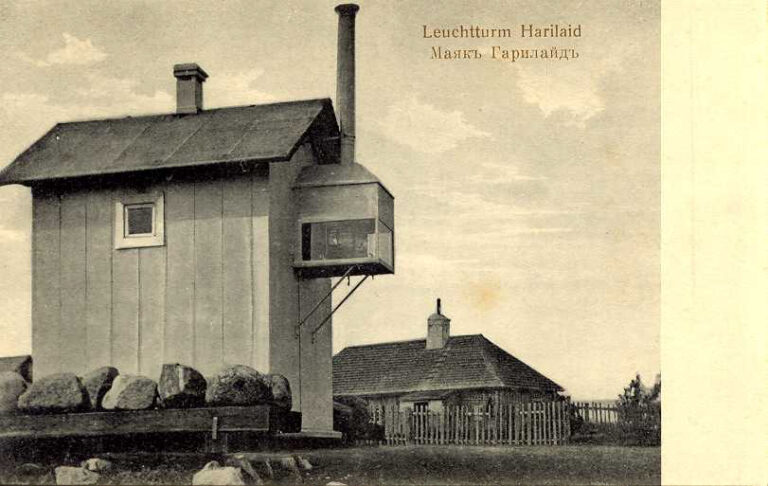
1885. In 2010, a fire tank similar to a white wooden house, about 4 m high, was built on the eastern shore of Harilaiu (58° 58.2' N, 23° 05.2' E), the lantern of which was initially powered by kerosene, later by gasoline. An alternating white and red light (40 times per minute) was visible in the sector SE 23° over E and N to NW 18°. The fire was 4m above sea level and visible for 4 miles. The southern edge of the fire sector was created by the wall of the gasoline storage 28 m away from the lighthouse, which hid the visibility of the fire above the Eerik rock.
1916. in 2008, the visibility of the fire tank was 7 miles.
1920. a new AGA acetylene lamp was installed.
1922. in the year the nature of the fire was: Fl W 4 s; 0.5 + 5.5 = 6 s.
1928. in 2015, the visibility sector of the fire was 162° over S and W to 337°.
1934. In 2010, a new wooden house was built on the lighting equipment.
1937. In 2010, a green sector light was added: white 162° over S to 265°; green 265° over W to 314°; white 314° to 337°.
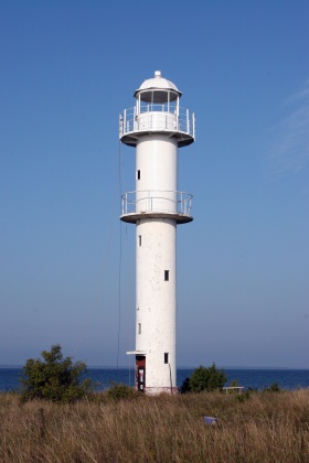
1940. in Harilaiu, a white 12-meter reinforced concrete lighthouse was built. It was set to a single target of 329° with the day mark and windlass, and the sectors of fire were also changed: white 24°-250.5°, green 250.5°-314°, white 314°-336.5°, red 336.5°-24°. In the wartime summer of 1941, the lighthouse was damaged by cannon fire, but was soon repaired.
1961. in 2014, the height of the light was 12 m above sea level, the visibility distance was 10/8/6 miles depending on the color. The nature of the fire had changed compared to before: Iso W/R/G 4 s; 2 + 2 = 4 sts.
1979. by 2015, the visibility distance of the light had been reduced: white 5, red 3 and green 2 miles.
1990. At the beginning of the 2000s, the light device EM-200 (ЭM-200) was powered by a radioactive isotope generator. Soon after disassembling the generators
1993. year, the lighthouse was equipped with an ML-155 lantern.
2006. In 2008, the Hailaiu lighthouse was raised by 7 m with a cylinder made of sheet steel and equipped with a new lantern room and another metal balcony. Nowadays, the lantern works on solar-wind energy and is equipped with a control system.