The lighthouse is located in Väinamere, 2 miles west of Rohuküla harbor, at the northern end of the small clearing Rukkirahu (Ruke-Rag). The sea mark helps to orient oneself in the shallow Väinamere, which is full of carrion, to avoid the shallows and to move to Heltermaa, Rohukülla, Haapsalu, Voosi kurku and also to head to the main Väinamere shipping route (Hari kurk - Viire kurk). Rykyrahu lighthouse forms
Hobulaiu with the southern fire tank Est 481, target 213.7°, which allows you to move safely in the Voosi gorge, from the Paralepa target to the Pinuks fire buoy near Hobulaiu.
From the northern end of Rukkirahu, a waterway dredged in 1916 leads nearby, which today is used for shipping between the mainland and Hiiumaa (Rohuküla - Heltermaa).
The first 11 m high white four-sided pyramid-like wooden day sign, with a square black shield above the boards, was installed to mark the waterway running to Haapsalu to Rukkirahu in 1860. The height of the tank above sea level was 12 m and the visibility distance was 7 miles. In 1895, a new wooden day sign similar to the previous one was built.
A new four-sided wooden lighthouse was erected in 1916 in connection with the establishment of the Rohuküla warship harbor and the dredging of the canal near Rukkirahu.
1922. in 2010, the height of the day sign without a lantern, which was topped with four-sided boards, was 17 m. In 1925, the tank was equipped with a flashing acetylene lantern, the light of which was 17 m above the ground and 19 m above sea level and was visible 9 miles away.
The lighting device was colored sector lights: white 13.5° over E, S and W to 283.5°, red 283.5° over N to 13.5°. By 1928, part of the white sector (107° above S to 197°) had been reddened additionally. Visibility of fire was 9 miles, nature of fire: Fl W/R 6 s; 0.3 + 0.9 + 0.3 + 4.5 = 6 s. By 1931, the 219°–246° sector was redone. During the 1933 repair, the old metal mast of the icebreaker Tasuja (ERA f 1091 n 1 s 1197 l 599) was installed in the center of the lighthouse.
A lantern was installed at the top of the mast, the light of which was 19 m above sea level.
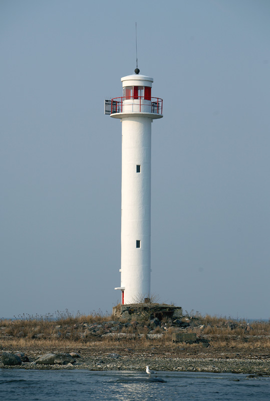
In 1934, the lighthouse received fire sectors: white 194°–284°; red 284°–14°; white 14°– 36°; red 36°–63°; white 63°–103°; red 103°–194°. The last division of fire sectors was used until the end of the century. Visibility range was 9 miles with white light and 6 miles with red light (TM 1934, 33). In 1940, a new 16-meter standard lighthouse of reinforced concrete was built, which was equipped with an automatic acetylene lantern. In the early 1990s, the lighthouse was powered by a radioactive isotope generator (the lantern had an L-200 (Л–200) lens). After the generator was removed in 1993, the lighthouse was transferred to solar-powered lighting equipment.