The lighthouses on the Sõru (Sõrro) bearing 310.6° are located on the southwest coast of Hiiumaa near Tohvri Peninsula, about 487 meters apart from each other. This bearing helps navigate the narrow shipping route of the shallow Soela Strait from Hiiu Strait to the Emmaste bearing.
The construction of the channel began in 1906 and was completed during the First World War. The first temporary wooden range lights to mark the fairway from the Väinameri to Sõru Harbor were established by the Hiiumaa Steamship Association in 1913. The permanent lights had a height of 5 meters for the lower light and 8 meters for the upper light above sea level. The lanterns were lit upon the arrival of the steamship association's steamships. These range lights also operated during the German occupation in 1918.
The range lights were re-equipped with lanterns in 1924. In 1925, a 7-meter unpainted wooden lattice tower was established on the southern side of Tohvri village (58° 42.2’ N, 22° 29.6’ E) for the lower light. The light in the tower had a 20° sector and was situated 10 meters above sea level, with a visibility range of 10 nautical miles, and its light characteristic was Fl W 1 s; 0.2 + 0.8 = 1 s. The upper 12-meter unpainted wooden lattice tower was located 469 meters away from the lower light on a bearing of 312.5°.
The light in the upper tower had a 20° sector, was 16 meters above sea level, had a visibility range of 10 nautical miles, and its light characteristic was Oc W 2 s; 2 + 2 = 4 s. In 1932, the upper tower had the following sectors: white 297.5°–3°, red 3°–44°, white 44°–74.5°, red 74.5°–171°.
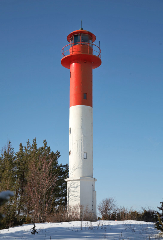
In 1934, concrete lighthouses were built, an 11-meter white lower one and a 16-meter gray upper one. Acetylene-powered automatic devices were installed in the lantern rooms, but the light characteristics remained the same as before. The lower lighthouse had a light height of 13 meters above sea level with a visibility range of 12 nautical miles, while the upper lighthouse had a light height of 19 meters above sea level with a visibility range of 10 nautical miles. The lower lighthouse's light was weak in the sector 278°–304°, strong in the sector 304°–321°, and weak again in the sector 321°–325°. The upper lighthouse was equipped with light sectors similar to modern ones.
During the events of 1941, the upper lighthouse in Sõru was damaged by cannon shells but was repaired in 1942.
By 1950, both lighthouses had been painted white at the bottom and red at the top. The light characteristics remained the same. In 1961, the lower range light had a visibility range of 10 nautical miles, the upper light had white light visible for 10 nautical miles, red light for 8 nautical miles, and green light for 6 nautical miles.
By 1983, the visibility range of the upper light had been reduced to 7/4/2 miles according to the color of the light.
In the 1980s, the lighthouses were converted to receive power from primary batteries and, in the late 1990s, they were connected to the general power grid. The lower Sõru lighthouse was equipped with an EMS-210 (ЭMC–210) light unit, while the upper one had an L-200 (Л–200) light unit.
As of today, the lighting systems of both range lights have been modernized. The current visibility ranges have been in effect since 2005.